Apr 07 2010

The Night Watch

Tag: failures,navigation,trips,Uncategorized,victoriesJonathon Haradon @ 8:21 pm

(post dated–this post generally refers to events on 3/29 and 3/30)

At midnight Karen grabs my foot and gives it a shake. I take off my eye mask and take out the earphones I’m wearing which along with my I-Pod and Sarah McLachlan, had me asleep in minutes three hours earlier despite the noise of the engine.  I was surprised at how much louder the engine sounds at night versus during the day.  I suppose the new soundproofing in the engine room was doing something, but I couldn’t tell.  I stumble around for about 10 minutes, getting dressed slowly and wobbly.  I can’t find my headlamp or my sailing knife.  I want some light and so switch on a light in the cabin, and quickly move the switch to the red light setting that is supposed to preserve your night vision.  The cabin now resembles a submarine on high alert.  I half expect Gene Hackman to barrel down the companionway yelling “down ladder!”  I imagine us on high alert.  Matt is up, walking around and off-handedly comments that he and Karen stopped using the red lights.  They don’t really provide enough light to do anything, which I quickly found to be true, and your eyes adjust fast enough when you are up on deck. High alert deflates immediately.  The engine continues to groan away as we travel through unfortunately light winds for our passage.  I plop down at the nav station to look at the log book and the AIS chart on the computer.  My night watch is about to start.

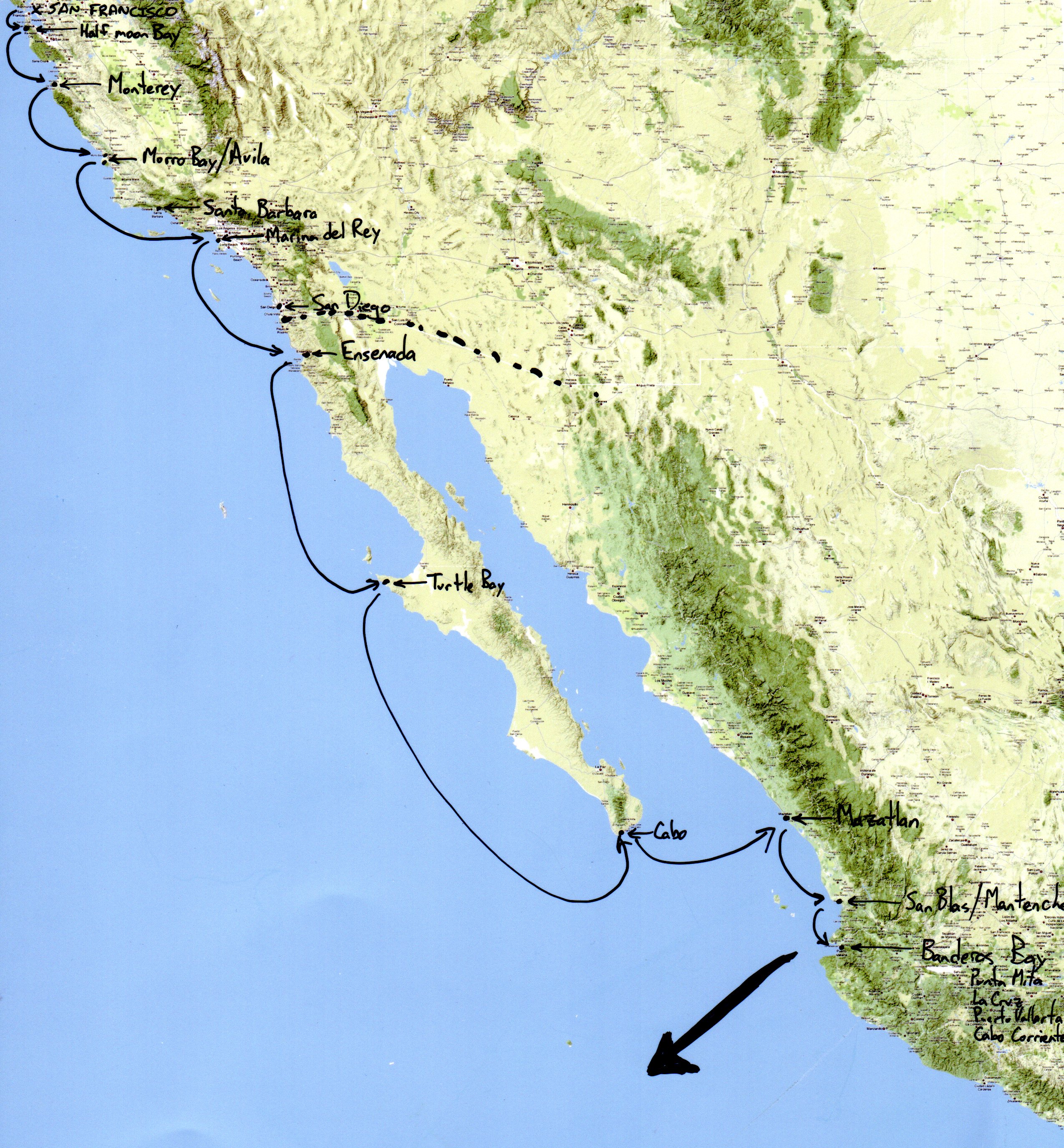
Before I even arrived, we had started talking about sailing a day or two north to San Blas.  However, the weather seemed to be less than ideal to the north, so Karen found a entry in the cruising guide that talked about a fine anchorage to the south that had some snorkeling and a fantastic sounding dinghy river trip.  South it was.  Next came talk of who was going to take what watch.  I knew this conversation was coming.  And i knew exactly what I wanted.  The night shift.  Wake me up at midnight or 1 am and send me out.  I wanted this for a number of reasons.  One, I feel, (it’s not just a feeling, I definitely am) behind in this obscure scale of mine that measures “personal discomfort” investment into the boat.  I don’t have much of this.  Matt has, well it’s somewhat amazing he hasn’t collapsed under the weight of how much he has endured.  Second, I wanted to experience as much of the cruising experience as possible.  Taking the night watch fit nicely there.  Finally, it just seemed the nice thing to do, to let Matt and Karen sleep together through the night.

After examining where we were on the AIS, I head up on deck.  Matt joins me and says we should put up the main sail and the drifter.  I’m super excited that we’ll actually be sailing on my watch, at least to start, instead of motoring.  It feels so much more pure.  After Matt helps me put up the sail, he heads off to bed, and I’m left alone on the night watch.  An alarm is set to ring every 23 minutes.  After two iterations of the alarm, I’m starting to get tired, and so lie down in the cockpit, realizing that I’ll be sleeping during some of this watch.  I’m looking directly up at the stars, and soon I’m dozing off, 1/2 awake, 1/2 asleep, dully waiting for the alarm to go off.  It does, I go through the watch routine, and quickly get back to lying down.  This time I’m out quickly.  Thirty minutes later Matt is in the companionway reaching out to the cockpit to hit my feet saying “Dude, you slept through the alarm.  You can’t do that.  Put the alarm closer to your head.”

On the night watch, there is one main responsibility.  Make sure the boat doesn’t hit anything.  Two lesser responsibilities are to 1) sail the boat well so you get to your destination faster. 2) control the boat so that it is easier for others to sleep.  Matt and Karen’s system they developed uses a watch that goes off at set intervals.  Pretty much all cruisers have an alarm set for certain intervals.  Matt and Karen have the watch set for 23 minutes.  So every 23 minutes, it’s the job of whoever is on watch to stand up, or wake up if necessary, look all around the horizon for other boats or land, and make sure you aren’t about to hit either of those.  It’s fascinating what you can see at night on the horizon.  All night we were in sight of shore so lights from there abounded.  At various times, other boats were on the horizon.  It’s enjoyable to spot lights on the horizon and watch over the next hour or two as they slowly move in relationship to the boat.  Of course if they are moving that slowly, it’s probably another sailboat.  The fast lights are the ones to worry about.  The cargo ships.

Matt disappears back down the companionway, leaving me alone fuming at myself.  My first night watch and I’ve made a HUGE mistake.  Damn it.  Not how I wanted to start.  Not the impression I wanted to make on Matt and Karen that I was a competent addition to the sailing team.  I am furious at myself and embarrassed.  Sure, the likelihood that at the exact interval I fell asleep 1) another boat would be just over the horizon that I couldn’t see on the last sweep, 2) wasn’t on the AIS that would alert me to boats further out, 3) was headed on a collision course with us and 4)  did not veer off that collision course because they of course don’t want to hit us…. yes the likelihood of all that happening is low.  Doesn’t matter.  Sleeping through a watch interval is way out of line.  I was not happy with myself.

Later in the night, the alarm goes off.  It is strapped to the band on my headlamp now, directly next to my ear, and so it wakes me immediately.  I get up and start to go through the routine I began to do at every alarm.  I rapidly check our compass heading and speed.  I then spend longer than necessary gazing in a slow 360 degrees off into the distance, looking for lights.  Each time I see lights, I get our binoculars (Thanks mom and dad!!!) and using the internal compass of them, note the heading to the lights and try to discern where it’s going.  If I see a red light, it means I’m looking at the port side of the other boat.  If I see green, I’m looking at the starboard side.  You can also tell things by the location and height of the white lights from a boat, but I’m not as sure about those. Need to learn that.  Next I slide down the companionway, moving as quietly as possible past the quarterberth where Matt and Karen are sleeping, generally with the door open to increase airflow and keep it cooler in the cabin.  I  have a seat at the nav station and take a look at the awesomest part of the night watch routine: checking the AIS transponder which is linked into the navigation software MacEnc, on the computer.  Matt has discussed his love for it in the past, and I have to back up that opinion 100%.  After checking the AIS both for ships and to ensure we are headed in the correct direction, I head back up on deck and do a quick scan of the horizon.  Finally, I look at our sails and see if they need adjustment.  Then it’s back to reading, writing or sleeping.

At 2:30 am on the second night, I watched us thread the needle between two 900 foot long cargo ships doing 14-18 knots.  I had seen the two ships when they were 20 miles away on the computer, long before I would be able to see them on the horizon.  Nonetheless, as soon as I saw them on the computer headed straight for us, I excitedly hopped up on deck, grabbed the binoculars, and stared out into space to where the boats should be.  I was met with nothing but blackness.   A black sky with foreboding moon and a glistening, flat, black sea.  An hour later however, I could see lights.  Lots of lights.  High, towering lights.  That still seemed to be coming straight for us.  The AIS, though, showed their actual heading, and ours.  We would pass the first to our starboard, by a mere mile.  The other, five minutes later, passed to port by even less, about 1/2 a mile.  I didn’t sleep at all for that hour, and gained an enormous appreciation for the additional safety the AIS brought us.  I saw them when they were over an hour away and knew their exact heading relative to us.  If we didn’t the AIS, they would have been twenty minutes or less away on an uncertain course that would have looked extremely troubling.  With the AIS, we didn’t have to divert our course, and I felt no danger to the boat, though I did anxiously watch the AIS and the horizon for the entire hour.  I certainly was too excited to sleep, this being only my second night watch.  But I felt confidently safe.  Without the AIS, I would have had to hail the vessel, not always possible, and try and figure out a way by both ships.  I can envision this being a confusing hail, with both boats so close, heading in the same direction and with the approximate same speed.  With the AIS, there was minimal concern.  The rest of the night passed uneventful.  My second night watch slowly winding down, I finished most of the novel I was reading, enjoying the near full moon as it arced lazily across the sky.  My first real introduction to cruising.  I think I’m going to like it.


Feb 28 2010

SPOT tracking

Tag: navigation,preparation,routemattholmes @ 3:28 pm

The AIS tracking feature has been a big hit as we’ve travelled down the coast of california, especially with concerned family.  However, once we leave the country we will be out of range of the shore-based AIS stations, and we won’t show up on the map except maybe in very popular international ports.

At the request of family and friends, we purchased a SPOT tracking device.  It cost $50 (after mail-in rebate), plus a $100/year subscription fee.  For our purposes, each time we press the “check in/ok” button on this little jobby, it communicates our position to one of their satellites, and then it shows up as a pin on our SPOT map, which I added to the sidebar and also to our “Current Location” page (a bigger version).  We plan on pressing the button about once a day; that will be our daily position report.  Supposedly it will have coverage in MOST places, including the coast of Mexico.  However! Important note that THE SPOT WILL NOT SHOW OUR POSITION WHILE WE CROSS THE PACIFIC, SO DON’T WORRY!

I have mixed feelings about this SPOT jobby.  The box it came in was hugely wasteful, with extra stupid pieces of cardboard, the website interface to get it working is terrible, their widget that I put up on our site messed everything up until I did some extra html coding, and even using the damn thing is extremely counter-intuitive.  It’s hard to tell when you’ve successfully turned it on, turned it off, or sent a signal, which is not so cool when you’re out in the middle of the ocean trying to figure out whether it worked to upload a checkpoint or not.  I anticipate it to be buggy, so mom please don’t worry if it malfunctions on us and you stop getting position reports.

So, to be clear: the lack of a daily check/in is not a cause for concern.  It probably means that we’re either having too much fun and forgot to press the button, or else that the piece-of-crap thing busted on us and is no longer working.

(fyi, the pins that you see on land in San Diego are a result of my initial testing right after we bought the SPOT, on foot and by bus; we left the boat in the marina)


Feb 20 2010

AIS–worth every penny

Tag: navigationmattholmes @ 2:00 pm

an example of why the AIS has been awesome.

In the middle of Karen and my night watch between Santa Cruz and Catalina, while we were still on the edge of the shipping lane, we were enveloped in dense fog.  I aimed us out of the shipping lane and turned on the radar, but the AIS was the true hero.

We had a 505′ container ship come up behind us doing 20 knots, and because I had the AIS and I could see where they were and where they were headed the whole time, I didn’t even have a need to hail them on the VHF, and never had any reason to worry about them.  They ended up passing less than a half mile to port of us–we never saw or heard them.  During all of this, the radar was most unhelpful.  When the ship was a mile away I could see her as a small blob on the radar (largely because I knew where to look from the AIS, and as she passed us at a half mile, the radar showed her as an amorphous blob extending for over 125 degrees worth of our horizon–as if an entire island was headed our way.

I took two screenshots from the AIS while it was happening, to show off here.  The first one shows the container ship passing us, the second one shows how we could see all sorts of other traffic headed out of LA, through which we passed uneventfully later that night.


Jan 28 2010

Final Preparations

Tag: navigation,preparationmattholmes @ 7:15 am

We intend to be ready to leave by February 7th, and then picking the first weather window after that would be acceptable for sallying forth into the ocean.  This is more or less the worse time of year to be sailing off the coast of California, so we intend to take a very careful look at the weather before we rush out to get bashed by unforgivingly cold wind and waves.

I have started experimenting with doing a “video journal”, uploaded to our youtube channel, which you can view by clicking on the video thumbnail in the sidebar (or by visiting the “videos” page).  I am not yet comfortable in front of the camera, and I’m still trying to remember to look directly at the camera lens while filming myself instead of at the screen (which results in me looking like my eyes are malformed in some awkward way).  But I think it is a valuable tool for me to capture some more candid and vulnerable moments that will make the trip more real for people who read this blog, and I will simply learn to deal with the constant feeling of looking like an idiot in the footage.

Today was the first day of sunshine in about three weeks, the second day it hasn’t rained.  The past week has been an exercise in tolerating the supremely unpleasant feeling of cold water dripping down my neck while stuffed upside down in the tightest spots of our cockpit lockers, blinding trying to snake wiring in the darkness for a dozen different electronic things mounted on the stern.

One of those things was our AIS transponder, which is a system that transmits our position, speed, and heading out into the void, and receives the same information from other ships that are doing the same.  When I plug the usb cable from the AIS into this very computer, all of those ships show up on my navigation software, complete with names, sizes, and sometimes even a picture (I uploaded our picture to the website).  Although the system is not dependent on the internet, various stations on shore pick up the AIS signals, and a couple of internet sites collect that information and plop it on a map.  Which means that when we happen to be close enough to a shore station, we will show up on the internet site in real-time.  You can spy on us at this very moment (if I happen to have the AIS turned on, that is.  It takes a little bit of power, so don’t count on it.)  The AIS provides a significant measure of safety against collisions with container ships–glad to have it.

My icebox somehow sprung a leak, which I discovered after spending two rainy days building elaborate storage shelves for said icebox.  It was a low moment–the icebox is my baby, my pride, I built the system from scratch, and it hurt me deep for it to be malfunctioning right before we are supposed to start our trip, broken in a way I did not comprehend, and without the proper tools aboard to fix it after we depart.  After a day of bumming about I kicked it into a higher gear, started staying up working on shit till midnight each night, contacted Kollman on his refrigeration forum for some advice, and developed a workable plan.  The icebox is back to working now (a video should be available for viewing on youtube in an hour or so), even though it probably still has a small leak, but I have obtained the tools I need so that I can fix it wherever we are, and that confidence has buoyed my spirits.  I feel somewhat ashamed to have reached a point where such a thing as a fridge could have such an impact on me, but it was just one more thing, a punch in the gut, when I didn’t need it.  A fridge is nothing in the scheme of things, but the symbolism couldn’t be ignored.  But I’m over it now.

Our good friends Pete and Ray are going to sail south with us for a month or so.  They are experienced sailors, and it brings me comfort to have them aboard for this first part of the trip.  Pete arrived yesterday, with my new chainplates in tow (his backpack was 80lbs–as weighed in at the airport), and has already finished fixing the windlass and started in on another project–which for boat work is light-speed fast.

Even though the shrouds aren’t even connected to the boat at the moment and the mast would fall over (literally) if we tried to leave the marina right now, I feel pretty optimistic that we will be ready to leave next week.  That’s saying a lot.  We’ve worked hard to be able to do it and we deserve it.  However, deserving it means nothing when you’re talking about a boat, and honestly I will be astonished if we aren’t delayed for some unforeseen reason, and that will be fine too.  But we are almost ready.


Nov 09 2009

“Where are you going?”

Tag: navigation,preparation,routemattholmes @ 4:17 am

Excellent question!  We’re leaving in January (worst weather off the coast of California is in January) and heading south down the coast to Mexico.  Then we will cross the pacific.  Maybe in March or April?  At this point we’re open to suggestions and easily influenced.

I have illustrated our basic plan on the diagram below, which admittedly is little better than a napkin sketch.

CheatSheetMap


So that’s my cheat sheet, to help me keep it all straight in my head.  “How do you know where to stop?”  is another excellent question.  I chose the stopping points on the map above largely from information gleaned from Louis and Laura, a fantastic couple who we are lucky to count among our friends.  I used to race on the bay with Louis and Laura until they sailed their boat Cirque down the coast; they have been cruising all over the coast of Mexico since then (i.e. good people to ask for advice).

On their recommendation, Karen and I visited Waypoint in Oakland, a store which specializes in charts and navigation-related boating information (the owners also have a winery in the warehouse next to the store–very cool).  We purchased two chart books and a cruising guide, and each night since then we have been spending a little time planning.

Maps of the sea are called “charts”.  Together with a compass, the chart is the foundation for navigation: it is used to figure out where you are, where you’re going, and how to get there.  Old-school charts (still readily available) are huge pieces of paper that you roll up and stuff in tubes to store, and then can never use because you can never flatten the damn things out again.  A “chartbook” contains the same charts cut up into conveniently sized 16″ x 22″ sheets and spiral bound.

The two chartbooks we purchased at Waypoint are titled “Southern California” and “Mexico to Panama“.  While sailing, one of these chartbooks will be open to the page for our location and we’ll plot our progress on it.

The charts are necessary for figuring out the route from port to port, but they don’t give information about where to go once you actually arrive.  Some of the things we need to know about each port are
1) are there any obstacles and dangers while trying to enter the harbor that aren’t marked on the charts?
2) can we anchor?  if so, where?  if we can’t anchor, what marina do we go to and how much does it cost per night for a slip?
3) where is the dinghy dock or beach (the convenient spot to tie up the dinghy while going about your business on land) and how much does it cost?
4) where is the fuel dock, if we need more diesel? 
5) where is the harbormaster’s office, so we can take care of any necessary paperwork?

The “cruising guide” is the source for this information.  The cruising guide consists of mostly text, with rudimentary charts of each harbor (sometimes hand-drawn).  I chose the “Mexico Boating Guide” by Rains; “Charley’s Charts” is another popular one.

And since I love maps and navigation, for extra credit I’m printing out 11″x17″ aerial photos from google maps of some of the anchorages in Mexico for which we have no detailed charts.  It’s amazing how much information you can glean from the aerial photo–you can see where the sailboats are anchored, and you can see where it’s shallow because the water changes color.  Also, it feels much more real and exciting when you can see other sailboats anchored out in the same spot where we will be.

Armed with these resources, we have been working out way down the coast, examining each port on the list we gleaned from Louis and Laura, looking at the charts and locating the anchorage, discussing the merits of whether to stop or skip each possible harbor down the coast.  Most of the harbors get relegated to the “backup list”, to be used in an emergency, or if we get too exhausted and need to duck in for a rest.  Some harbors–like Marina Del Rey and Ensenada on the map above–get the special nod as ideal places to resupply food or diesel.  Others are unavoidable: Turtle Bay for example is pretty much the only protected harbor between Ensenada and Cabo San Lucas.

So we have the charts and the cruising guide and we know where we’re going to start and where we might visit, and that’s enough for now!